This article investigates the possibility that China and India conflict on water insecurity. Water scarcity alone cannot cause armed conflict; rather, it requires “upstream-downstream positioning, sovereignty linkages, and political instability,” as Jin H. Pak has pointed out. Sadly, the Brahmaputra River already has all three of these elements. There is more pressure to implement contentious water diversion plans in China due to its lack of water and growing north-south water divide. India will be put in danger by these ambitions, particularly as the Brahmaputra River passes through a region of contention. These elements may make war more likely, together with China’s shifting internal circumstances. Mega Dams built along the border rivers can trigger conflict in the near future.
Introduction
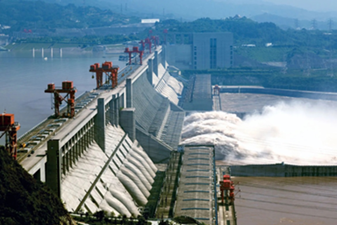
Despite having 18–19% of the world’s population, China and India only possess 4–7% of the freshwater resources. The already unstable situation has been made worse by the severely unequal distribution of water resources, poor water management, a large population, contaminated water, and climate change. To overcome this, China plans to build the world’s largest hydroelectric dam in the foothills of the Himalayas, the location of the first Tibetan Empire established by the ancient Yarlung civilization. This planned mega-dam might create up to three times the amount of hydroelectric power produced by the Three Gorges Dam, which is currently the largest dam in China and is situated on the Yangtze River in Yichang in the Hubei Province of central China.
Research Questions
- How can water be a source of conflict?
- How is the population growth impacting water demand in China and India?
- How significant is the Brahmaputra River?
- What is China’s water diversion plan?
- How alarming is the super dam to India?
Literature Review
The construction of large-scale hydropower dams in China, such as the Three Gorges Dam, has significant effects on the water dynamics of the region and India’s geopolitical ties. Academics like Wang (2012) and Chen & Jin (2017) draw attention to China’s strategic emphasis on hydropower as a vital element of its economic growth and energy security. Simultaneously, historical conflicts and present talks over shared river basins such as the Brahmaputra and Indus have impacted Sino-Indian water relations (Bandyopadhyay, 2015; Panda, 2018). These mega-dams have substantial negative effects on the environment and society; research by the WWF (2019) and Xu & He (2016) highlights worries about biodiversity loss, sedimentation, and community uprooting. Geopolitically, the construction of dams in border regions raises strategic considerations and potential points of conflict (Kumar, 2017; Roy, 2019). Legal frameworks and institutional mechanisms for transboundary water cooperation are essential, as discussed in works by UNESCO (2009) and Biswas & Tortajada (2018). By analyzing these dimensions, this paper aims to elucidate the multifaceted implications of China’s hydropower development on Sino-Indian water relations and regional stability.
Water: An Instrument for Conflict
Goethe once stated, “Everything is sustained by water, and everything originated in the water.” This statement is entirely accurate. Water is one of the most essential gifts from nature because of its many applications. Its accessibility has a significant impact on human health, development potential, affluence, and ability to sustain life. The world’s abundant resources appeared to be limitless when the population was less. This is no longer feasible, though, since the exponential growth rates of the human population, businesses, and farms have already lowered the amount of water available to less than the about 23 litres per person per day that is required as a minimum.
Just 3% of the world’s water is fresh, and of that, around 77.7% is trapped in polar icecaps and glaciers and unavailable for human consumption, highlighting the severity of the issue. Groundwater makes up 22% of freshwater. The world population has tripled in the past 70 years, yet due to industrial expansion and rising irrigation needs, water consumption has climbed sixfold. Through the mining of surface and groundwater, supplies have also multiplied to meet up with demand. The overuse of groundwater resources as a result causes a shortage of groundwater. Many basins’ surface water resources are being overused, and siltation is rapidly causing them to disappear. The availability of fresh water is rising.
Tensions inside and between nations have arisen as a result of the increasing strain on freshwater supplies. Aquifers, lakes, and rivers that make up more than half of the world’s freshwater supplies are shared by two or more nations. One of the longest rivers in the world, the Nile, which passes through eleven nations, serves as an excellent illustration. Due to the region along the Nile River’s water shortage, Ethiopia, an upper riparian state, and the lower riparian states of Egypt and Sudan have historically been at odds with one another. Egypt is primarily dependent on the waters of the Blue Nile River, and Ethiopia’s building of the GIBE Dam is the current source of contention between Ethiopia and Egypt. In this regard, Anwar Sadat, the president of Egypt at the time, declared that Egypt would never again go to war—that is until it was necessary to defend its water resources—after signing the Peace Accord with Israel in 1979.
Water may also be purposefully used as a weapon. For example, severing the freshwater supply in a certain area puts pressure on the people in that area. As seen by the collapse of the Kakhovka Dam in Ukraine, which devastated entire towns, flooded farms, cut off electricity and clean water to tens of thousands of people, and severely damaged the environment, water services are frequently the victims of war. One of the worst industrial and environmental catastrophes to hit Europe in decades is the collapse of the Nova Kakhovka dam in southern Ukraine. It is yet hard to determine if the dam’s collapse was due to intentional damage or if a structural failure may have resulted in the breach. Because the hydroelectric power plant and dam are under Russian jurisdiction, outside investigators are unable to visit them. As a result, specialists from all around the world are attempting to piece together what happened based on scant visual evidence.
Between 1990 and 2023, at least 1,473 incidents of violence, conflicts, and water-related problems were documented globally. According to statistics released in December 2023 by the US-based non-profit Pacific Institute, almost 72% of these occurrences happened between 2014 and 23. Even more concerning is the tendency from 2019. Data from the Pacific Institute shows that between 2019 and 2023, there were at least 671 instances of water-related violence globally.
Based on research from the Pacific Institute, the two biggest worldwide hotspots for water-related conflicts are Asia and Africa. Approximately 80% of all wars globally are located in these two regions. Ismail Serageldin, vice president of the World Bank, aptly summarizes a widely held belief on water and security: “The Wars of the next century will be about water.”
Growing Demand for Water
China
China with a world population of 20% and only 7% of water resources faces water scarcity heavily caused by pollution. Not to mention, in the present scenario, China’s Ministry of Environmental Protection has itself considered a quarter of China’s river water so dirty as to be unsuitable for necessities of life such as drinking, agriculture, and even industrial use.
China, being an almost entirely water-independent nation due to its renewable freshwater supply that originates from the rivers within the country faces geographically uneven distribution of surface water.
Its freshwater resources are mainly located in the country’s south and southwest, benefitting that region’s farms and factories while leaving the wheat-producing heartland and industrial north dry. This imbalance has led Beijing to undertake a progressive hydrological engineering plan called “South to North Water Diversion”.
A second factor to China’s water crisis besides the disparity of water supply between the North and South is “Pollution”. Pollution being one of the major global concerns has even affected the water-rich areas of China. It is causing a decline in the supply of clean and usable water within the country and to quote what the estimates say, “70% of China’s rivers and lakes are currently contaminated, half of China’s cities have groundwater that is significantly polluted, and one-third of China’s landmass is affected by acid rain. Today, most of China’s Yellow River is unsuitable for swimming leaving the experts calling it “cancerous”.
India
The 2018 Composite Water Management Index report by the National Institute for Transforming India has stated that India is facing the worst water crisis in its history.
India has 18 percent of the world’s population but only 4 percent of its water resources, making it one of the most water-stressed countries causing approximately 600 million people to experience high to extreme water stress and 200,000 deaths annually due to inadequate access to safe water.
With nearly 70 percent of India’s water being contaminated, The Interconnected Disaster Risks Report of 2023 says “By 2030, India’s water demand is projected to double the amount and leading this scarcity to affect millions and adversely impact the country’s GDP as well. Yale University’s 2022 unsafe drinking water index ranked India 141 out of 180 countries saying it is enough of India’s water condition.
The Tibetian Plateau
Tibet, sometimes known as the “Third Pole,” is home to the world’s greatest freshwater reserve after the Arctic and Antarctica, and it has granted China unrestricted access to permanent water supplies. Over 2 billion people are supported by the ten major river systems of Asia, which rise from the Tibetan Plateau and flow through eleven different nations. In all, the rivers that originate on the Tibetan Plateau supply water to seven significant river basins in Asia. The Indus (China, India, Pakistan), Brahmaputra (China, India, Bangladesh, Bhutan), Salween (China, Burma, Thailand), Mekong (China, Laos, Thailand, Cambodia, Vietnam), and Sutlej (China, India, Pakistan) are the ones that are significant to China’s neighbours to the south and southeast. These rivers receive seasonal runoff from over 45,000 glaciers. It makes sense that Tibet is so significant to China and is known as the “Water Tower of Asia.” In addition to providing China access to Tibet’s abundant natural resources, China’s political dominance over the 2.5 million square kilometre Tibetan Plateau has given it enormous influence. While water scarcity still affects three-fifths of historical Han China. The People’s Republic of China today, however, is incredibly water-rich because of its forced annexation of the Land of Snows. Similar to how Saudi Arabia is an oil power, China is a water power due to its control over the “blue gold” richness of the Tibetan plateau. Indeed, China has the potential to regulate the ecological sustainability of numerous significant river systems because of its sovereignty over Tibet. China has recently been focusing more and more on the exploitation of water resources on the Tibetan plateau. This is because the region offers several enticing locations for massive projects, to a nation that has long believed in conquering nature with little consideration for the long-term ecological effects and, due to which, it has also resulted in India being concerned over the activities in it’s three main rivers (Brahmaputra, Indus and Sutlej)
The Brahmaputra River: Course and Significance
The Brahmaputra River, one of India’s most important and recognizable rivers, is also referred to as the Yarlung Tsangpo in Tibet. This massive river rises in the Himalayas, travels through Bangladesh, India, and Tibet, and then empties into the Bay of Bengal. The regions that the Brahmaputra River passes through are vital to their economies, cultures, and ecosystems.
The river rises in strength from tributaries as it travels eastward for approximately 700 miles between the Kailas Range to the north and the main Himalayan range to the south, starting with the Angshi Glacier on the Tibetan Plateau. The river flows at the highest average elevation of more than 12,000 feet through Tibet, making it the world’s highest-flowing river system.
The river flows through the Tibetan city of Pei before turning northeast and creating the renowned Great Bend in Nyangtri Prefecture. It flows through a sequence of rapids and cascades in these little gorges before heading southwest and south to pass through the Grand Canyon of the Tsangpo, which is the world’s longest, steepest, and deepest canyon. The canyon is around 7,440 feet deep on average, and at its lowest point, it is 19,714 feet deep, more than twice as deep as the Grand Canyon. The Brahmaputra has the greatest slope deflection of any river surface in the world, at 75.35 percent, as it winds through the canyon. If the river is tamed, the geology presents the possibility of massive hydropower generation.
Following its exit from the Tibet Autonomous Region, the river flows into Arunachal Pradesh, the region’s governance is still up for debate between China and India. China had taken control of this 56,000-square-mile region during their 1962 border battle, but India still holds sovereignty over it. Beijing continued to reject India’s authority over the area even after it voluntarily retreated to the current effective line of demarcation. One of the biggest possible flashpoints influencing Sino-Indian ties is still the ensuing border dispute, along with confrontations over other disputed border parts.
The river then flows into the northeastern Indian state of Assam, where it receives water from more Himalayan tributaries before becoming the Brahmaputra. Even in the dry season, this river is strong, and in certain places, the distance between its banks during the rainy season is almost six miles.
It is impossible to overestimate the significance of the Brahmaputra River to India. The Northeastern part of the nation, which includes seven states (Assam, Arunachal Pradesh, Nagaland, Manipur, Meghalaya, Mizoram, and Tripura), depends on it for survival. Over 130 million people reside in the delta of the Brahmaputra River in Bangladesh and India. Over six lakh of these people depend on the yearly “normal” floods to replenish the soils of the flood plains with moisture and new sediments. A wide range of human endeavours, including farming, fishing, transportation, and tourism, are made possible by the river. In addition, it provides an essential supply of water for hydroelectric power generation and irrigation, both of which are essential for the region’s economic growth.
The Brahmaputra River basin is estimated by the Central Electricity Authority to hold around 44% of India’s total hydropower potential. The Brahmaputra basin’s “exploitable hydropower potential” is projected to be 58,356 MW, whereas India’s total hydroelectric potential is estimated to be approximately 150,000 MW.
China’s Ambition
The wording in the Chinese government’s November framework of the 14th Five-Year Plan, which outlines national development goals between 2021 and 2025, was the catalyst for the most recent tensions between China and India. “Implement… the downstream hydropower development of the Yarlung Zangbo River,” according to the text, was the goal. Beijing refers to the first 2,840 kilometres of the river as the Yarlung as it winds through Tibet. After that, it crosses the Sino-Indian Line of Actual Control and becomes the Brahmaputra, passing through a disputed region that China claims is southern Tibet and India considers to be Arunachal Pradesh. The river then flows 1,856 kilometres farther across Bangladesh and India before draining into the Bay of Bengal.
There is fierce competition for water resources as irrigated agribusiness and other water-intensive businesses proliferate. Tension arises from the enormous population, inefficient water sharing, scarcity of water, growing middle-class demand, and glacier melting negatively affecting the rivers that originate in the Tibetan Plateau. Chairman Mao originally recommended projects like the “South to North Water Diversion” in 1952 to alleviate water shortages in cities like Beijing and Tianjin to solve hydrological unevenness. Later, when there was a severe water crisis, China suggested the Great Western Route and the South-North Water Diversion Project as water diversion projects. China has traditionally adhered to the Shou-tian Concept, which involves reversing the flow, to supply water to its dry northern region.
The Project for South-North Water Diversion (SNWDP): Mao Zedong was the one who first popularized the concept of South-North Water Diversion in 1952. It addresses interior waterways. The Chinese formally started the project in 2002 to transfer 44.8 million cubic meters of water from the Yangtze River in the South to the Beijing and Tianjin regions in the North, as the need for water in the Northern regions grew. It intended to build three routes—the Eastern, Central, and Western—that would cross the high-altitude Qinghai Tibet Plateau and connect to the Northern Region. In 2014, the Yangtze and Han Rivers’ water was effectively transferred to the Yellow Rivers via the Eastern and Central channels, increasing the amount of water available to Beijing, Tianjin, and the provinces.
The Great Western Water Diversion Plan (GWWDP): It is a transboundary river-based water diversion project that is significantly more ambitious. Through a convoluted network of reservoirs, tunnels, and natural rivers, it seeks to redirect water from the upstream portions of six rivers in South-West China—including the Mekong, Brahmaputra, and Salween Rivers—to the arid regions of Northern China. The proposed “Grand Western Canal,” which would transfer 50 billion cubic meters of water from the Brahmaputra to the Yellow River, is especially concerning to India. According to reports, China is studying methods for creating the longest tunnel in the world—1000 km—for this purpose at an estimated cost of $150 billion. The goal is to transmit water to Xinjiang’s Taklimakan desert and the country’s largest administrative division. When such a tunnel is built, there are concerns that it may disrupt the Brahmaputra’s water flow and result in floods, droughts, and irreversible harm to Bangladesh’s and India’s natural and ecological systems.
Dam Building Spree
In the 14th Five-Year Plan (2021–25), the Chinese government intends to build a “super hydropower dam” on the Yarlung Tsangpo, according to a story published in Global Times on November 29, 2020. The hydroelectric project would be “meaningful for the environment, national security, living standards, and international cooperation,” according to the assessment.
The super dam is situated in a location that was long believed to be unpassable, among the most dangerous landscapes on Earth. China finished building the Three Gorges Dam, one of its largest-ever undertakings, in 2003. Despite the intense controversy surrounding this enormous project, many claimed that the nation benefited overall from its ability to produce clean energy and prevent regular disastrous floods near the Yangtze River.
Presently, China is initiating an even more vast undertaking by building the first “super-dam” globally on the Yarlung Tsangpo River. This is a high-elevation segment of the Brahmaputra that traverses through Tibet under Chinese sovereignty and flows towards India and Bangladesh. This massive project intends to harness the Tsangbo’s deep canyons, which are more than twice as deep as the enormous Grand Canyons in the United States, to produce an estimated 60 million kilowatts of hydropower. This is over three times as much hydroelectric electricity as the Three Gorge power plants produce. But because the massive dam is being constructed in a seismically active region, it is the riskiest project in the world. This implies that it could be a ticking time bomb for Bangladesh and India downstream.
India’s Concern
The Helsinki Rules on the Uses of the Waters of International Rivers are international guidelines governing how rivers and their connected ground waters that cross national boundaries may be used. They were adopted by the International Law Association (ILA) in Helsinki, Finland in 1966. China was required to consult with the two neighbouring countries, but it failed to do so.
The Chinese plans to build dams and divert waters from Yarlung Tsongpo should be viewed in the context of the tense relations that exist between India and China, as well as the latter’s poor record of sharing hydrological data, the effects of its dam construction on other shared rivers, such as the Mekong, which have an impact on the lower riparian states, and—above all—China’s tendency to act unilaterally while concealing its intentions. Wide-ranging negative effects are estimated from the Brahmaputra River’s damming and diversion. Below are some of the main issues raised.
Ecosystem and Livelihood
If the annual flooding cycle is permanently disrupted by significant upstream damming and diversion, millions of people will be impacted by changes to and loss of nearby flood plains. It could seriously impair the downstream countries’ economies and devastate their ecosystems.
Floods
Dams in seismically vulnerable places have the potential to trigger earthquakes and floods, which might devastate the lower riparian areas and result in fatalities and large-scale migrations. Numerous events have occurred in the past. Floods on the Sutlej River in June 2000 devastated Himachal Pradesh, resulting in 200 fatalities and damage to the hydroelectric Naptha Jhakri plant. Previously, in May 2000, devastating floods in Arunachal Pradesh caused enormous damage and loss of life and property due to a break in one of the dams on the Yarlung River in Tibet. The Indian government assigned its remote sensing agency to conduct a more thorough investigation into the floods because of the unexpected nature of the events and China’s unclear response. It was established in the 2000 report that the recent flash floods in Arunachal Pradesh were caused by a break in the Tibetan Dam “after monitoring the complete technical details and pictures of the site.” Are there plans to build several dams on the Brahmaputra River in Tibet, which could lead to the recurrence of incidents similar to those in Arunachal Pradesh, Assam, and West Bengal? Keep in mind that the Brahmaputra River discharges 19,300 cubic meters per second (cusecs) on average, but during floods, that amount can increase fivefold to over 1,00,000 cusecs. Due to their proximity to the border, dams like Zangmu, Jiexu, Dagu, Jiexu, and the upcoming super mega dam at Metog/Dadugia are significantly more susceptible to earthquakes (or manipulation) and the disastrous consequences they can have on the downstream regions.
Seismic Activity
In 2008, an earthquake on the Tibetan plateau claimed the lives of over 8700 people. Chinese specialists focused their investigation on the Zipingpu Dam, which is situated close to a geological fault line and may have produced tectonic stresses that subsequently triggered an earthquake. This has increased the likelihood of earthquakes and floods because several dams are being built in seismically vulnerable areas closer to the Indian border.
Hydrological Data
China is required by the terms of the Memorandum of Understanding (MoU) signed in October 2013 to furnish hydrological data on trans-border rivers for the monsoon season, which runs from May 15 to October 15, every year. However, no data was released in 2017 against the backdrop of the Doklam standoff, supposedly because of the “upgradation and renovation of the Data Collection Center in Tibet.” Bangladesh did, however, simultaneously affirm that they had received the hydrological data for the same river on time, validating India’s concerns that China would use water as a diplomatic (and possibly military) leverage point during tense times. Additionally, it was noted at the beginning of November 2017 that the Brahmaputra’s water was unsafe for human consumption due to its dull, black colour and high iron and cement concentration. India claimed that this might have resulted from the Chinese construction of infrastructure on the Brahmaputra River, which was being built before it entered India. China, on the other hand, claimed that an earthquake in Southeast Tibet was to blame for the turbidity of the Brahmaputra River and denied any involvement on its part. The US Geological Survey’s data analysis, however, disproved the Chinese assertions, demonstrating that an earthquake with a magnitude of 6.3 had struck Nyangtri (Nyingchi) in Tibet on November 18, well in advance of the river becoming murky. These events substantiate China’s opaque actions on the Brahmaputra River as well as its reluctance to divulge hydrological information and other specifics that have an immediate impact on the lower riparian states.
Current Scenario
India launched its largest hydroelectric project, an 11,000 megawatt (MW) project in Upper Subansiri, Arunachal Pradesh, out of fear of Chinese “water wars.” In response to Chinese dams nearing its borders in the northeast, India is also moving quickly to approve three stalled projects for potential distribution to the NHPC based on the advice of an appraisal committee and the Ministry of Power’s in-principle approval.
Beijing released new maps of China on August 28, claiming possession of the entire Aksai Chin region and parts of Arunachal Pradesh, shortly after Delhi announced the resumption of its dam construction. China is mostly in charge of Aksai Chin, but India claims it belongs to the broader Kashmir territory. China has long claimed sovereignty over the whole of Arunachal Pradesh.
The development of the “largest hydroelectric power facility” in the nation was approved by the Modi administration in March 2023. It is located in Arunachal Pradesh on the Dibang River, which is a tributary of the Brahmaputra. The estimated cost of this project is close to USD 4 billion.
According to sources, India’s 2,000 MW Lower Subansiri projects are intended to minimize flooding if China releases exceptionally high volumes of water and, in addition to producing power, help alleviate water scarcity for up to a year in the event of a Chinese diversion. Given that China owns 50% of the Brahmaputra river basin, the hydroelectric projects that are booming in the northeast, particularly in the border state of Arunachal Pradesh, are perceived as a calculated move to offset the possible effects of Chinese flow diversion through the dams that China is building.
Conclusion
There are concerning signs for the world at large and its neighbours specifically regarding the rise of an expansionist China and its long-term aspirations to secure natural resources, particularly water. Being the upper riparian state, China has all the advantages when it comes to the transboundary water resources between India and China. In India, its intentions to dam the Brahmaputra River have caused significant concern. It is concerning that dams may have an adverse effect not only on the way of life and nutrition of the people who depend on the Brahmaputra River for their livelihood but also on their ability to survive in the event of devastating earthquakes and floods. India must also be aware of China’s potential and, maybe, its intention to use water as a weapon when necessary. To guarantee that China abides by the established principles, norms, and regulations on sharing trans-border rivers, India must thus develop a well “thought-out” and “thought-through” strategy in collaboration with other lower riparian and like-minded states and international organizations. Before beginning trans-border river projects that could have far-reaching and perhaps disastrous impacts, China must ensure that it respects the interests and concerns of lower riparian nations.
Disclaimer: The views and opinions expressed by the author do not necessarily reflect the views of the Government of India and Defence Research and Studies
Title image courtesy: Britannica


References
1. Wu, A., & Lantham, A. (2023, March 29). Darkening waters, gathering storm: Sino-Indian water war on the Brahmaputra river. E-International Relations. https://www.e-ir.info/2023/03/29/darkening-waters-gathering-storm-sino-indian-water-war-on-the-brahmaputra-river/
2. Zamlha, T. G. (n.d.). China’s ‘super dam’ a threat to India’s security. Central Tibetan Administration. https://tibet.net/chinas-super-dam-a-threat-to-indias-security/
3. Zhang, H. (n.d.). Sino-Indian water disputes: The coming water wars? ResearchGate. https://www.researchgate.net/publication/283975182_Sino-Indian_water_disputes_the_coming_water_wars
4. Chaturvedi, A. K. (2022). Water: A source for future conflicts. Centre for Joint Warfare Studies. https://cenjows.in/wp-content/uploads/2022/02/book3.pdf
5. Chellaney, B. (2011). Water: Asia’s New Battlefield. Georgetown University Press. https://www.researchgate.net/publication/236219049_Water_-_Asia’s_New_Battleground
6. Kremer, D. K. (2012). The past, present and future of water conflict and international security. International Studies Perspectives, 13(4), 374-389. https://onlinelibrary.wiley.com/doi/full/10.1111/j.1936-704X.2012.03130.x
7. Donnellon, G. (n.d.). Hydro-hegemon? Complexities of shared rivers between China and India. Lowy Institute. https://www.lowyinstitute.org/the-interpreter/hydro-hegemon-complexities-shared-rivers-between-china-indiaREFERENCES