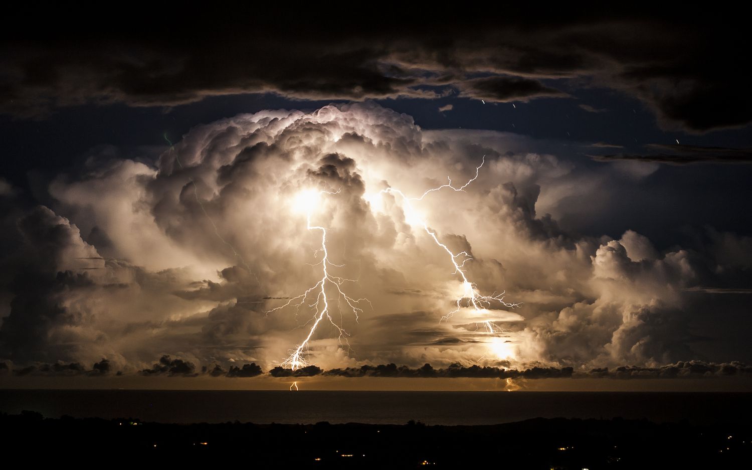
Thunderstorms are severe weather phenomena, whose impact is being increasingly felt by all sectors of society, whereas lightning is one of the major contributors to death in natural disasters.
Knowledge of thunderstorm climatology, including its frequency, intensity, diurnal variation, and duration, is essential, particularly for safe air navigation. In this article, we will examine the distribution of thunderstorm activity in the Indian region. This will help pilots, dispatchers, controllers, and operators understand the most active areas and routes in those areas.
Thunderstorms are one of the most spectacular weather phenomena offered by nature. A giant cumulus cloud developing into a towering dark cumulonimbus accompanied by lightning flashes and thunder is a sight to watch. During the summer season, the common man looks at the majestic and towering thundery cumulonimbus with hope, because the oncoming showers provide relief from the scorching heat. While farmers welcome thunderstorms for rains and consequent benefits, the aviator dreads it and tries to keep away from it, as a thunderstorm is a well-known hazard to aviation and a large percentage of aircraft weather-related accidents have been due to thunderstorms. Most of the high-impact weather phenomena on mesoscale like hailstorms, heavy rain and squalls are caused by thunderstorms.
Impact of Thunderstorms in India
- Severe Thunderstorm activity during pre-monsoon and monsoon periods.
- Most tornadoes are associated with Kalbaisakhs.
- India has the highest frequency of hailstorms in the world.
- India has the highest casualty associated with lightning strikes.
- The frequency of occurrence of thunderstorms in India is second only to that in central regions of the United States.
- Major aviation hazards with several incidents and accidents.
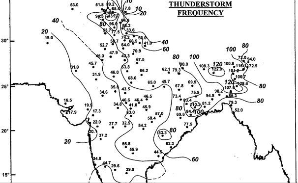
Annual Frequency
- The areas of highest activity of thunderstorms exceeding 120 days in the year are seen over Assam, Sub Himalayan West Bengal and the windward side of Pir Panjal range in Jammu and Kashmir.
- The region of high thunderstorm activity (more than 100 days) are Jammu sub-division in the north Assam, Meghalaya and adjoining parts of Bangladesh and West Bengal in the east followed by Kerala ( 80-100 days).
- The least number of thunderstorms (5 days) in the country occur in Ladakh.
- In the plains, the lowest occurrence is seen over Saurashtra and Kutch (15 days). Thunderstorm activity increases as one moves northeastwards from Saurashtra and Kutch across Rajasthan (20 to 40 days), Haryana (40 to 50 days), Punjab and Uttar Pradesh (50 to 70 days) to Himalayan foothills (80 days).
- The frequency of thunderstorms over central parts of the country is between 30 and 50 days. The frequency increases eastwards and is between 50 and 80 days over Bihar, east Madhya Pradesh, Chhattisgarh, Telangana and coastal Andhra Pradesh and Orissa. The frequency increases to 80 to 100 days over Gangetic West Bengal and Bangladesh and between 100 and 120 days over Sub-Himalayan West Bengal, Assam and adjoining northeastern states.
- Thunderstorm frequency is between 20 and 40 days over Madhya Maharashtra, Rayalseema and adjoining north Karnataka and shows an increase southwards.
- The frequency is between 40 and 60 days over Karnataka and northern parts of Tamil Nadu and between 60 and 80 days over Kerala and adjoining south Tamil Nadu. Bay islands record between 50 and 70 days of thunderstorm activity.
Seasonal Distribution
Winter
- The country as a whole records the lowest number of thunderstorms during the winter season. It is primarily due to stable and dry atmospheric conditions prevailing over most parts of the subcontinent except for Sri Lanka and southern Kerala.
- The highest frequency during this season is over Sri Lanka (16 days) associated with northeast monsoon activity.
- The second maxima (13 days) is seen over the windward side of the Pir Panjal range over Jammu and the adjoining region. This maxima is associated with western disturbances.
Pre Monsoon
- The pre-monsoon season is characterised by an increase in thunderstorm activity over all parts of the country with a significant increase over northeast India, Bangladesh, West Bengal, the south peninsula and the Jammu region.
- The highest frequency of more than 40 days is observed over Meghalaya and adjoining Assam, Sub-Himalayan West Bengal and Kerala and more than 30 days over the rest of northeast India and parts of Bangladesh and West Bengal.
- In the north, the Jammu sub-division records the highest frequency (25-30 days) of thunderstorms in the pre-monsoon season. Topography, insolation and advection of moisture under favourable wind regimes contribute to thunderstorm maxima over these areas.
- In the plains, the lowest frequency of 2 to 3 days is observed over Gujarat between 5 and 10 days over Rajasthan, West Madhya Pradesh and north Maharashtra and between 10 and 15 days over Indo Gangetic plains and the rest of the peninsula.
- Thunderstorm frequency increases to 15-20 days over East MP, Chhattisgarh, Orissa and adjoining parts of Andhra. Thunderstorms occur between 20 and 30 days over West Bengal and adjoining Jharkhand and Orissa, South Tamil Nadu and Karnataka.
Monsoon
- The country as a whole outside Kerala records the highest frequency of thunderstorms during monsoon season. Availability of moisture and favourable synoptic features contribute to the general increase of thunderstorm activity over all parts of the country outside Kerala.
- The highest thunderstorm activity in the country continues to be over northeastern states, Bangladesh, West Bengal and adjoining states, which record more than 50 days of thunderstorms during the season with a maximum of 70 days over Sub-Himalayan West Bengal.
- Most thunderstorm activity over Rajasthan, Gujarat, Madhya Pradesh and northern parts of Maharashtra is caused by westward-moving monsoon lows and depressions whereas over Tamil Nadu, Andhra Pradesh and adjoining areas thunderstorms occur during weak/break monsoon conditions.
Post Monsoon
- The country witnesses a marked decrease in thunderstorm activities.
- Thunderstorm activity increases as one moves southwards along the west coast and east coast.
- The highest number of thunderstorms during this season occur over Kerala (20 to 25 days) whereas the neighbouring state Tamil Nadu has a frequency of 10 to 15 days. Higher activity over the south peninsula is associated with retreating monsoon and easterly waves.
Remember, as you head east and north in India, the frequency increases. The other hot spot is coastal peninsular region of the country. Thunderstorms can form at any time, in any season and in any place but there are hot spots and risky seasons as covered in the blog above. Every pilot should know about them. Line Squalls/Severe storms (Kalbaisakhs) are more likely to be found from Apr to Jul in the eastern part of the country.
Avoiding Thunderstorms
- The short and easy answer is: Just don’t get into the storm to begin with. Keep more than 20 miles of distance from big cells. Farther is better.
- The only way to avoid the threat of microbursts is to avoid storm cells on approach or take off path. Despite ample caution, these incidents keep happening.
- Extreme turbulence, severe icing, hail loss of situation awareness, overstressing of aircraft and lightning are various hazards in the storm. More often a simple turnaround is the best solution.
- Wise use of available information, and judicious use of aids are the first line of defence.
- Trying to find gaps could be tricky and dangerous.
- Understand the stage of a thunderstorm by looking at its size, colour and edges.
- Keep diversion as a plan always ready when negotiating large areas of convective weather. Divert before it’s an emergency.
Lightning Strikes
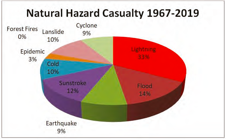
Deaths caused due to lightning account for 33% of total fatalities due to natural hazards in India. This is also the highest in the world.
- Lightning is a global phenomenon and at any given time more than 2 billion lightning strikes take place.
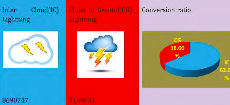
- Lightning is a natural electrical discharge of very high voltage and short duration between cloud and ground (CG) or within cloud (IC).
- The science of lightning is called Fulminology.
- The fear of lightning is called Astraphobia.
- Thunderstorms being a short-term phenomenon, it is extremely difficult to pre-warn the population of an impending lightning strike.
- To address this hazard, a Lightning Resilient India Campaign was launched by the Indian Met Dept on 26 Mar 2019. With joint efforts from IMD, ISRO, MoES, NRSC, IRCS, UNICEF and State Departments awareness campaigns and early warning messages have helped reduce the deaths by almost 50 % in 2021.
Lightning strikes (Intercloud (IC) and Cloud to ground (CG)) were mapped for the entire country. The figures depict the total lightning strikes from 01 Apr 2019 to 31 Mar 2020. The data shows that 1 out of 3 lightning strikes the ground.
The figure below depicts the month-wise lightning activity over India for the year 2019-20.
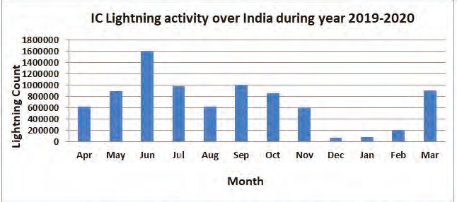
The lightning activity is observed to be maximum during Jun, Sept, Oct, and Jul and in that order while minimum in Dec and Jan. Maximum lightning strikes are observed in Odisha, Madhya Pradesh, Maharashtra and West Bengal, while maximum deaths due to lightning were observed in Uttar Pradesh, Madhya Pradesh, Bihar and Odisha. See the chart below. The reasons could be attributed to higher population density as well as more people working in the open due to agriculture-based activity.

Lightning Strikes Across States
The study of data has further revealed that
- Lightning is a very localised phenomenon. Within a state, it may vary due to topography, coastal region or urban and industrial area.
- Lightning has been observed mostly in the second half of the day. However, due to weather activity, it may occur during any time of day.
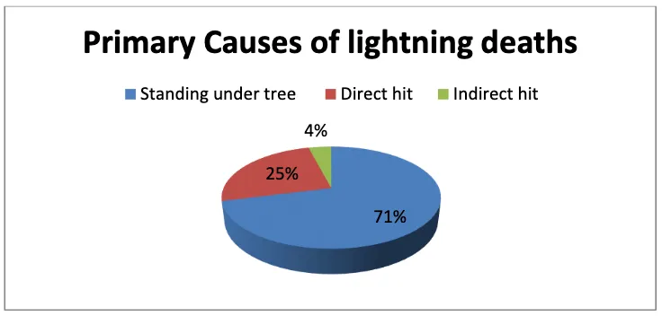
- 60-70% of deaths occur in rural areas e.g. farmers working in fields, tin huts, standing under a tree.
The Lightning Resilient India Campaign has been a collective effort of organisations and individuals. It has an ambitious goal of zero lightning deaths. The tough journey continues and it aims to utilise science for the good of humanity.
If you are required to work in the open like on an airfield, request your operator to provide lightning alerts. You can also save your life by reading about preventive steps and downloading the app developed by the Government of India. Some tips are listed below for people working at the airport.
If you’re outdoors
- Take cover: Go inside a sturdy building or a bus/car with the windows closed.
- Avoid objects that conduct electricity: Avoid Tin shades or poles or ladders, GPU or AC trolleys.
- Avoid open spaces: Don’t stand under trees, or use walkie-talkies or mobiles.
- Avoid elevated areas: Get off the ramp or ladder.
- Stop Refuelling activity.
- Do not use headsets for communicating with the flight deck.
If you’re indoors
- Avoid using electrical appliances of any kind.
- Wait: Wait at least 30 minutes after the last thunder before going back outside
If someone is struck by lightning
- Call airport emergency immediately
- Give first aid, including CPR, if the victim is not breathing
- Move the victim to a safe place
- Use an automatic defibrillator if there’s one nearby
The lightning threat is real and remember one out of three lightning strikes Earth. If you are working in areas or months where and when lightning poses a threat brief your colleagues and friends about the danger. It will save lives one day.
India Meteorological Department
IMD is the principal government agency of the Government of India for all weather and climate services. It functions under the Ministry of Earth Sciences (MoES) with its headquarters at Mausam Bhawan, Lodhi Road, New Delhi. It has six regional centres and 26 meteorological centres at the state level. The India Meteorological Department was established in 1875 with HF Blanford as Meteorological Reporter. From the modest beginning in 1875 to at present, IMD boasts 39 Doppler Weather Radars for better observation and prediction of extreme events across the country by 2023, along with INSAT 3D/3DR dedicated weather satellites providing every 15 minutes cloud imagery. About 200 Agro-Automated Weather Station (Agro-AWS), 806 Automatic weather stations, 1382 Automatic Rain gauges, and 83 lightning sensors along 63 Pilot balloon upper air observation stations serve as the backbone of weather observation services of IMD throughout the country. And true to its growth, I have been witness to the increasing accuracy and reliability of forecasts and trends. IMD’s range of services has also expanded enormously to sectors like Agriculture, Aviation, Shipping, General Weather, Hydrology, Power, Health, Transport etc.
Title image courtesy: https://www.thoughtco.com/
Disclaimer: The views and opinions expressed by the author do not necessarily reflect the views of the Government of India and Defence Research and Studies


Article courtesy: https://vayuacademy.com/blog/
Reference:
1. Evolution of Indian Meteorological Department, https://rsmcnewdelhi.imd.gov.in/images/pdf/Evolution_of_IMD.pdf
2. Thunderstorms, Naresh Kumar, IMD.
3. Thunderstorm Climatology over Indian Region, Ajit Tyagi, Mausam,